Update, 8:45 p.m.:
Civil Defense, Young Brothers and everyone lifted the Tropical Storm watch. We dodged the bullet again. Thanks, everyone!
***
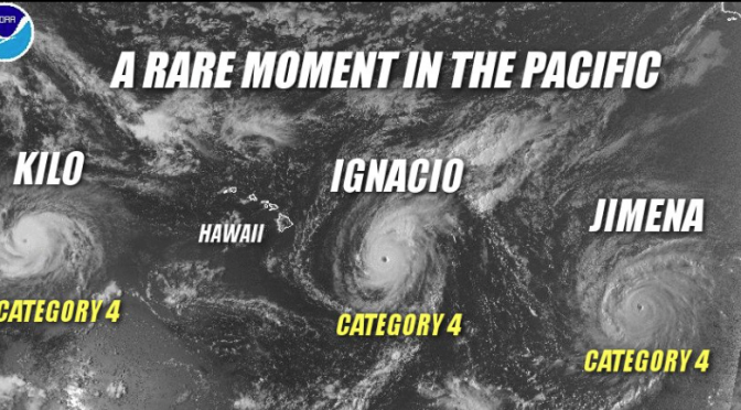
It’s been quite a hurricane season already this year!
Right now we are watching Ignacio. At 2:45 p.m. today, Hawaii County Civil Defense announced that Hurricane Ignacio was posing an “anticipated reduced threat.” It’s still a Category 3 hurricane, currently with sustained winds of 115 miles per hour and higher gusts, and right now it’s about 380 miles east of Hilo moving 12 miles per hour to the northwest. They say it’s gradually weakening.
Everything indicates, too, that it’s moving more to the north of the islands now and will move parallel to the Hamakua coast. This is good, but what worries me is the size of the hurricane. As it moves along its path, spinning counterclockwise, its winds affect us on the Hamakua coast first. This is a big coastline up alongside a mountain, so it operates like a valley. The winds come from the north and are forced up against the slopes of the mountain. The energy doesn’t go over the top of the mountain, but runs down the slope and is concentrated along the Hamakua coast from the north to the south.
That’s why we’re still a bit concerned about this one. That’s good news that it’s weakening, but its winds are still 115 miles per hour and it only takes 55 mph winds to flatten a banana tree.
So they can say what they way to say, but at the moment those winds are traveling at 100-something miles per hour, so am I going to go catch a plan to Honolulu because I’m so sure nothing’s going to happen here? I don’t think so!
But we’ve secured everything at the farm that needs to be secured. So we’ll wait and see.
Take care everyone. The update from Hawaii County Civil Defense is here:
This is a Hurricane information update for Sunday August 30th at 2:45PM.
As of 2:00 PM this afternoon Hurricane Ignacio was continuing on a northwest track at 12 miles per hour and remains a category 3 hurricane. Ignacio was located approximately 380 miles east of Hilo and recording sustained winds of 115 miles per hour with higher gusts. Hurricane force winds extend outwards from the center up to 30 miles and tropical storm force winds extend outward up to 160 miles.
Although the National Weather Service Tropical Storm Watch for Hawaii Island remains in effect, the present track and gradual weakening of Ignacio is presenting with an anticipated reduced threat to Hawaii Island. Based on the anticipated and improved forecast outlook, evacuation centers will not be opened at this time. The Civil Defense Agency will continue to maintain close communication with the National Weather Service and monitor the system.
All DOE public schools and private schools will be open tomorrow.
In addition all government offices will be open for normal business.
The High Surf Warning issued for the east facing shores of Hawaii Island will remain in effect through 6:00PM Tuesday evening. Surf heights are expected to increase today and build to possibly 15 to 20 feet. Residents in low lying coastal areas and boat owners are advised to take necessary precautions.
Please monitor your local radio broadcast for additional updates.
Galen Mizuguchi liked this on Facebook.
Michelle Tomboc liked this on Facebook.
Jan Kama liked this on Facebook.
Anthony Hastie liked this on Facebook.
Trish Shaner Knudsen liked this on Facebook.
Kevin Cockett liked this on Facebook.
Fred Smith liked this on Facebook.
Stay safe!
Take care my friend! Hoping teh winds continue to drop in speed.
RT @richardha: Hurricane Ignacio Update: Sunday 2:45 p.m.: It’s been quite a hurricane season already this year! … http://t.co/zYIKKXTom3
Gina L. Keawemauhilikeaweamahi liked this on Facebook.
Leslie Peter DeBina liked this on Facebook.
Eric Paul D’Almeida liked this on Facebook.
Ric Costorio liked this on Facebook.
Robin Hammerquist liked this on Facebook.
Joni Kamiya-Rose liked this on Facebook.
Lorie Farrell liked this on Facebook.
Jeff Steiner liked this on Facebook.
Sally Waitt liked this on Facebook.
Glenn Hayakawa liked this on Facebook.
Joy U Mahi Madriaga liked this on Facebook.
Boni Narito liked this on Facebook.
Robert Nakano liked this on Facebook.
Patricia A Cangemi liked this on Facebook.
Robert Elliott liked this on Facebook.
Good Luck! Richard Ha